Saturday, November 29, 2014

Old fold mountains of India

Young growing Sivalik hills 
(of the outer Himalayas)
&
 worn down old fold mountains 
(of Indian peninsular plateau)

1. Sivalik range are the hills, where one can see the geologically young tectonic activity
rise of the fragile hills of the outer Himalayan range year by year

2. And to it's south are the 'northern fertile plains of Ganges

3. At the southern end of these plains are the region where Indian peninsular plateau starts with 
a. it's 5 old fold mountains mostly Archian in age, 
b. worn down due to weathering with no tectonic plate activity underneath.
The Sivalik hills are the southernmost and geologically youngest mountain range of the outer Himalayas
The tectonically active zone of the Himalaya, are considered as the most dynamic formation where they annually rise up by 3 to 4mm. As being very young in geological formation and tectonically active, the hills exhibit a very conspicuous fragile terrain, they are bounded on the south by a fault system called the Main Frontal Thrust.


Old fold mountains
(5 hill ranges of Indian peninsular plateau)
1. Old fold mountains are characterized by having stopped growing higher 
due to the cessation of upward thrust caused by the stopping of movement of the tectonic plates 
in the Earth's crust below them

2. In ancient times they were extremely high 
but since have worn down almost completely by millions of years of weathering.

3. The cratons are mostly Archaean in age and are generally composed of 
low-grade greenstones. (Dharwar, Eastern Ghat, Aravalli and Satpura)


1. Aravalli range Literally meaning 'line of peaks', a range of mountains in western India running approximately 800 km in a northeastern direction, are the oldest fold mountains in India. The northern end of the range continues as isolated hills and rocky ridges into Haryana state, ending in Delhi. The famous Delhi Ridge is the last leg of the Aravalli Range, which traverses through South Delhi and terminates into Central Delhi where Raisina hill is its last extension. It is one of the world's oldest mountain ranges. It dates back to a pre-Indian subcontinental collision with the mainland Eurasian Plate. The southern end is at Palanpur near Ahmedabad, Gujarat.(text credit:http://en.wikipedia.org/wiki/Aravalli_Range)
The system is divided into two sections: the Sambhar-Sirohi ranges, taller and including Guru Peak on Mount Abu, the highest peak in the Aravalli Range (5,650 feet [1,722 metres])(text credit:http://www.britannica.com/EBchecked/topic/32222/Aravalli-Range)

2. Satpura Range The name of which means 'Seven Folds', range of hills, part of the Deccan plateau, western India. The hills stretch for some 560 miles (900 km) across the widest part of peninsular India, through Maharashtra and Madhya Pradesh states. The Satpura Range includes the Mahadeo Hills to the north, the Maikala Range to the east, and the Rajpipla Hills to the west. Highest point of satpura range Dhupgarh is located in Pachmarhi.(text credit:http://www.britannica.com/EBchecked/topic/525030/Satpura-Range)

The range rises in eastern Gujarat state near the Arabian Sea coast, running east through the border of Maharashtra and Madhya Pradesh to the east till Chhattisgarh. The range parallels the Vindhya Range to the north, and these two east-west ranges divide Indian Subcontinent into the Indo-Gangetic plain of northern India and the Deccan Plateau of the south. The Narmada River originates from north-eastern end of Satpura & runs in the depression between the Satpura and Vindhya ranges, draining the northern slope of the Satpura range, running west towards the Arabian Sea. The Tapti River originates from eastern-central part of Satpura, crosses the range in the center & further runs at the southern slopes of Satpura towards west meeting the Arabian Sea at Surat, draining central & the southern slopes of the Satpura Range. The Godavari River and its tributaries drain the Deccan plateau, which lies south of the range, and the Mahanadi River drains the easternmost portion of the range. The Godavari and Mahanadi rivers flow into the Bay of Bengal. At its eastern end, the Satpura range meets the hills of the Chota Nagpur Plateau.(text credit:http://en.wikipedia.org/wiki/Satpura_Range)

3. Vindhya range 'Vaindh' (to obstruct) or 'Vindhya' means 'hunter' in Sanskrit, and may refer to the adivasi (tribal) hunter-gatherers inhabiting the region, refers to a complex, discontinuous chain of mountain ridges, hill ranges, highlands and plateau escarpments in west-central India, located to the north of the Narmada River.
A series of hills connects the Vindhya extension to the Aravalli Range near Champaner.
A southern chain of runs between the upper reaches of the Son and Narmada rivers to meet the Satpura Range in the Maikal Hills near Amarkantak.

4. Western Ghats( the Sahyadris) Forming the western edge of the Deccan tableland, the Western Ghats run in north-south direction, parallel and close to the Arabian Sea coast, from the Tapi valley to a little north of Kanniyakumari for a distance of 1,600 km. यह वास्तविक पर्वतश्रेणी नहीं है वरन प्रायद्वीपीय पठार का ही एक भ्रंश कगार है। यह उस भ्रंश का द्योतक है जो अफ्रीका से भारत के अलग होते समय उत्पन्न हुआ था।

5. Eastern Ghats Bordering the eastern edge of the Deccan Plateau, the Eastern Ghats run almost parallel to the east coast of India leaving broad plains between their base and the coast. In striking contrast to the continuous eminence of the Western Ghats, it is a chain of highly broken and detached hills starting from the Mahanadi in Orissa to the Vagai in Tamil Nadu.
#author wishes thanks to Ms Padmavati Pandey for her extensive support during researching this topic.  
#reference cited links are thankfully quoted at appropriate place.

Tuesday, November 11, 2014

Mahabharat period and Chhattisgarh

Mahabharat period
There are astrological, natural, geographical, physical, inscriptional and scriptural evidences that unquestionably establish the date of epic Mahabharat war as 3139 BC
“Vishva Panchangam”, established in 1925 and published by  
Kashi Hindu Vishvavidyalaya (Benares Hindu University), Varanasi. 
It gives all the three eras: Kali era, Vikram era and (Shalivahan) Shak era.
It says on page 3 that 5,100 years have already elapsed before 2056 
Vikram year which is 1999 AD. It means that the existing Kali era is 5101 
in 1999 AD, which comes to (5101 - 1999) 3102 BC.
credit: http://www.thevedicfoundation.org/bhartiya_history/mahabharat.htm

छत्तीसगढ़ की जातीय एवं सांस्कृतिक परम्पराओं में महाभारतकालीन इतिहास की एक झलक  
1.छत्तीसगढ़ में सदियों पुरानी महाभारत के पांडव नायकों की जोश और ओज़ पूर्ण साहसिक-गौरव-इतिहास के प्रस्तुति की सांस्कृतिक-परम्परा का पंडवानी गायन, 2.महानदी तट  के राजाओं का पाण्डव वंशी इतिहास, 3.सिरपुर-चित्रांगदपुर-चेदि देश और कालांतर में छत्तीसगढ़ के पाण्डव वंशी सम्बन्ध, 4.'पहाड़ी कोरवा 'और  'पंडो 'आदिम जनजातियों का महाभारत कालीन  'कौरव 'और  'पांडव' से जुड़ी उनकी मान्यताएं ....
Tribes of Bastar
यह सभी पौराणिक लिंक एवं संकेत, छत्तीसगढ़ के इतिहास को और समझने तथा लिखने के लिए दिशा-निर्देश का काम करते हैं !!  

'Panduvanshi' history of Chhattisgarh 
History of Chhattisgarh or South Kosala can be traced back only from the 4th century AD. Between the 6th and 12th centuries AD the Sarabhpurias, Panduvanshi, Somvanshi, Kalchuri, and Nagvanshi rulers dominated this region.    

More historical links of Mahabharat period
As Pandvas spent their 'hiding-period' (अज्ञातवास) in these hills of south Koshal, while staying all along the banks of Mahanadi river.
courtesy:http://www.oocities.org/siliconvalley/screen/3299/history/maps.htm
So various places of Chhattisgarh have found reference in the epic book of Mahabharat; as states won by Sahdev named Prakkosal, Aranya (अरण्य ) areas of Bastar were referred as Kantar state and places won by Karan (करण) is called Kosal janapad (कौसल जनपद).
Chitrangada's father Chitravas was the king of Chitrangadpur (Sirpur). Vabhruvahan, son of Arjun and Chitrangada was the king of Chedi.

Maikal mountain ranges of Satpura
temple at Kawardha (1349, Fadinagvanshi king Ramchandra)
Stone inscriptions (शिलालेख) found from different places on the banks of Mahanadi river as in Sirpur, Rajim, Aarang states that kings of this region called them self Pandav and regarded Vabhruvahan as their ancestor. It is believed that Chedidesh state of Vabhruvahan was later called Chedigarh and then on Chhattisgarh.
http://sciencedoing.blogspot.in/2014/11/history-of-chhattisgarh-in-nutshell.html

Mahabharat-period link of 'Pando' and 'Pahadi Korwa' tribes of Chhattisgarh
Major population in Chhattisgarh comprises tribal population. Among the primitive tribes are Pando and Korwa, who still live in forest. The Pando tribe believe themselves as the member of "Pandav" clan of epic Mahabharata. The Korwa tribe believe themselves to be the member of "Kauravs" of Mahabharata.
http://en.wikipedia.org/wiki/Surguja_district
 
The main concentration of Hill-Korwa tribe is in Jashpur, Sarguja & Raigarh. According to Anthropological description of family they belongs to Austro-Asiatic family.
http://cjtdp.cg.gov.in/tribes.htm
http://www.ethnologue.com/language/kfp 

#reference cited links are thankfully quoted at appropriate place.
#author wishes thanks to Ms Padmavati Pandey for her extensive support during researching this topic. 

Saturday, November 1, 2014

History of Chhattisgarh in a nutshell

Though a separate state of Chhattisgarh became reality

when it was declared the 26th state of India on 1st November 2000;

but the history of Chhattisgarh 
goes back to tens of thousands of years !!

Anthropological evidences
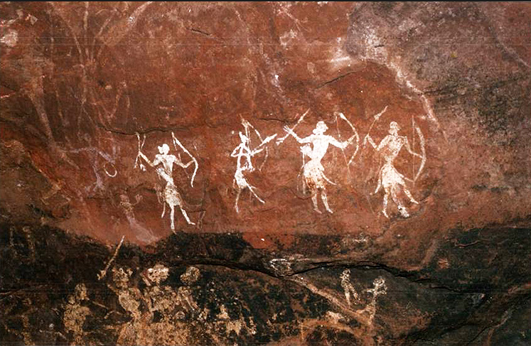
The anthropologists have found evidences of some of the earliest human habitations in the rocks and cave of this ancient land.
pic courtesy:http://www.bradshawfoundation.com/india/pachmarhi/
Hstorical evidence of rich human habitation starts from the 'Stone Age', as Singhanpur caves of Raigarh district and Kabra hill rock painting are about 30 to 50 thousands years old.
*http://www.cgculture.in/archaeology/Rock%20Art%20Site%20In%20Chhattisgarh.htm
*http://www.bradshawfoundation.com/india/pachmarhi/
*http://www.indiamike.com/india/chhattisgarh-f148/trip-report-to-singhanpur-caves-raigarh-t179119/
*http://wikimapia.org/13583821/Singhanpur-Caves 

Mythological history:
The mythological history of Chhattisgarh region stretches back to the period of Ramayana and Mahabharata. According to legends the deep Sal forest regions are Dandakaranya itself, where Lord Rama spent much of his fourteen-year exile from Ayodhya.

Ramgarh hill site where caves are caves and paintings are ound
bill board depicting possible route of Rama,s travel through these places

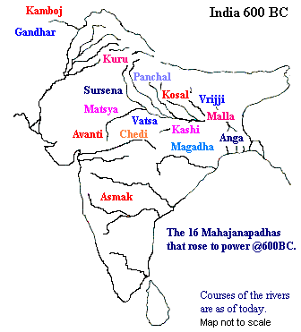
South Kosal or Maha Kosal was an old name of Chhattisgarh, which differentiated it from Kosal of north i.e. Ayodhya and Shrawasti. 
Bastar region of Chhattisgarh also named as Kantar or Mahakantar or Dandakaranya.

As per reference in Ramayana, Koshilya the mother of Rama was the daughter of King Bhanumant, who belonged to the family of a powerful king dynasty Kosal, south of Vindhyan mountain near Nagpattan. As Bhanumant had no sons, after marriage of his daughter to Ayodhya king Dashrath, this Kosal state was annexed to his state.

As Rama, Laxman and Sita spent much of their 14 year exile in Dandakaranya, there are many places related to their sojourn and stay. Ram devotee Bhil lady Shabri was born in Shivarinarayan.

Various places of Chhattisgarh have been referred in Mahabharat. 
States won by Sahdev named Prakkosal, Arany areas of Bastar were referredf as Kantar state. Places won by Karn is called Kosal janapad.

Chitrangada's father Chitravas was the king of Chitrangadpur (Sirpur). Vabhruvahan, son of Arjun and Chitrangada was the king of Chedi.
Temples at Rajim, called Triveni of Chhattisgarh
Ballabhachary birth place, Champaran near Rajim

Stone inscriptions (शिलालेख) from places on the banks of Mahanadi river; Sirpur, Rajim, Aarang states that Kings of this region called them self Pandav and regarded Vabhruvahan as their ancestor. It is believed that Chedidesh state of Vabhruvahan was later called Chedigarh and then on Chhattisgarh.
Ramgarh range of hills
Ramgarh hill
Cave painting in Ramgarh hill
Cave writing in Ramgarh hill
Drama stage at the cave site of Ramgarh hill

Caves of Ramgarh hills in Surguja have two stone inscriptions in Pali script of Buddha period. These two stone inscriptions of Sita Bengra and Jogimogra are believed to be of Ashoka period. 
This inscription refers to Sutanuka (a देवदासी) and her lover Devdeen. 
Sita Bengra cave have an amphitheatre of Buddha period.

Kotadola, a place west to Ambikapur, there is a Ashoka's three lion emblem inscribed on a stony structure, which supports the idea that Ashoka's kingdom was all up to this place

Like that in the north east of Kawardha, a Rishabhdev's beautiful statue believed to be of Mahavir period.
Jain Teerhankar idol found at Maheshpur
Unbroken history chain of Chhattisgarh
History of Chhattisgarh or South Kosala can be traced back only from the 4th century AD. Between the 6th and 12th centuries AD the Sarabhpurias, Panduvanshi, Somvanshi, Kalchuri, and Nagvanshi rulers dominated this region. 

The medieval period
This region came to be known as Gondwana and became the part of the kingdom of the Kalchuris who ruled the region till the end of the 18th century AD.
*http://throughpicture.blogspot.in/2012/10/culture-embeded-in-stone-maheshpur.html
*http://throughpicture.blogspot.in/2012/11/stony-emotions-from-maheshpur-india.html
Excavation site at Maheshpur
Vishnu and other idols found in Maheshpur
Shivling found in Maheshpur
Madwa Mahal temple at Kawardha (1349, Fadinagvanshi king Ramchandra)
Bhoramdev temple, Kawardha, called Khajuraho of Chhattisgarh, belongs 1349, Fadinagvanshi king Ramchandra


The Mughal period
The Muslim chroniclers of the 14th century AD have described well about the dynasties that ruled over the region. The region also came under the suzerainty of the Mughal Empire around the 16th century and later to the Marathas in 1745. By the year 1758, the whole region of Chhattisgarh was annexed by the Marathas. Also the word 'Chhattisgarh' was popularized during the Maratha period and was first used in an official document in 1795.

Colonial era
With the British entry in the early 19th century, much of the territory was subsumed into the Central Provinces. From 1854 onwards the British administered the region as a deputy commissionership with its headquarters at Raipur. 

#Chhattisgarh also took part in the 1857 Revolution when Vir Narayan Singh, a landlord of Sonakhan, grew up to challenge the injustices of British rule in the region. After a prolonged battle with the British forces, Vir Narain Singh was finally arrested and later hanged on the 10th December 1857. 

#In the year 1904 British reorganized the region and transferred Sambalpur to Orissa and added the estates of Surguja to Chhattisgarh.
*http://throughpicture.blogspot.in/2013/03/architecture-with-endemic-flavour.html
Emblem of Surguja state
Revenue stamp of Surguja state
Kothi Ghar, The Palace, traditiopnal seat of governance of Surguja state

T S Singhdeo, Maharaja of Surguja state, now MLA from Ambikapur
Note of thanks for share and citation courtesies:
*For the family tree of Ratanpur king Mayurdhwaj, refer to A.Cunningham, Archaeological Survey of India 

 https://archive.org/search.php?query=creator%3A%22Archaeological%20Survey%20of%20India%22
*Refer to Nelson and Dr. Heeralal for Bilaspur gazetteer for the family tree of Kalchuri kings of Ratanpur and Raipur branch
*some text references thankfully consulted from a book, Chhattisgarh (2003 edition) by Dr.Kaushlendra Tripathi and Dr.Purushottam Chandrakar
*some text reference thankfully shared from:http://www.tourismofchhattisgarh.com/tourism-of-chhattisgarh/history-of-chhattisgarh.html
*author extends thanks to Ms Padmavati Pandey for her valuable input and meaningful discussions during the preparation of this post.

Pineal gland, the mystical third eye

Pineal gland   It is a very small unpaired midline brain structure of endocrine gland, tiny as a rice grain size, situated laterally (anatom...